
A new U.S.-India satellite called NISAR (NASA-ISRO Synthetic Aperture Radar) has been hailed as a critical part of a pioneering year for U.S.-India civil space cooperation by both President Trump and India’s Prime Minister Modi during their visit in Washington in February. The NISAR launch will advance U.S.-India cooperation and benefit the U.S. in the areas of disaster response and agriculture. The satellite launch is scheduled for July 30 from Sriharikota, India if all goes well.
Here are five key points about the NISAR mission:
1️⃣ 3D Earth Monitoring
- NISAR uses two advanced radars to map Earth’s land and ice in 3D.
- It detects surface changes down to a fraction of an inch.
- Can see through clouds and light rain, day or night.
- Enables continuous observation of earthquakes, landslides, glaciers, and Antarctica’s ice sheet.
2️⃣ Hazard Detection & Planning
- Provides early signals for earthquakes, volcanoes, and aging infrastructure.
- Helps officials monitor faults and volcanic regions for potential danger.
- Assists in evaluating structural stability near critical infrastructure such as dams and levees.
3️⃣ Groundbreaking Data Capabilities
- Features dual-radar tech: L-band and S-band, each with specialized sensitivities.
- Produces up to 80 terabytes of data daily—unmatched by previous Earth-observing satellites.
- Data is cloud-distributed and available for public use.
- Demonstrates powerful NASA-ISRO collaboration.
4️⃣ Ecosystem Monitoring
- Covers nearly all land and ice surfaces every 12 days.
- L-band radar penetrates deep into forests; S-band radar is great for crops.
- Supports studies on forests, wetlands, agriculture, and permafrost dynamics.
5️⃣ Historic NASA-ISRO Partnership
- First major collaborative mission of its kind between NASA and ISRO the I
- Radars built separately and integrated by cross-agency engineering teams.
- Builds on decades of SAR (Synthetic Aperture Radar) innovation from both agencies that allows satellites to bounce radar signals off the ground and interpret the echo – it can even peer through clouds.
- Represents a milestone in global Earth science cooperation.
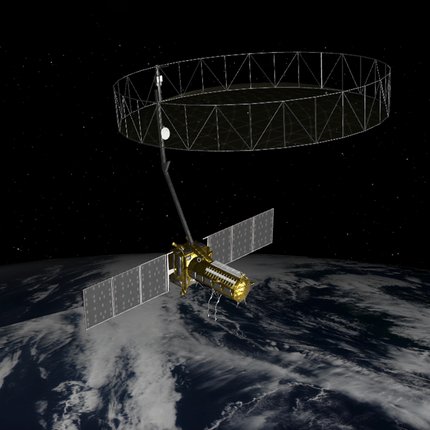
Real-time 3D view of NISAR spacecraft in its planned science orbit
Image courtesy: NASA
Last updated: December 26th, 2025

